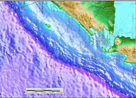
The western Indonesian fore-arc basins extend more than 1800 km from northwest of Aceh to southwest Java. The width of the basins varies from less than 70 km south of the Sunda Strait to about 120 km in the west off northern Sumatra. The basins form a strongly subsiding belt between the elevated Sumatra Paleozoic–Mesozoic arc massif cropping out along Sumatra and Java, and the rising outer arc high.
(Contributor: Dieter Franke, BGR)
Seismic Sections:
 Figure 1. Location map of line ABB-SO-137-31, south of Banten, West Java.
 Figure 2. NW-SE oriented uninterpreted section of line ABB-SO-137-31. Data courtesy: BGR
 Figure 3. Interpreted section of line ABB-SO-137-31. Data courtesy: BGR
 Figure 4. Location of line ABB-SO-137-36
 Figure 5. SW-NE orientation seismic line ABB-SO-137-36. Data courtesy: BGR
Figure 6. Interpreted seismic line ABB-SO-137-36. Data courtesy: BGR